Geofencing solves exactly this problem. It's the technology that turns a map boundary into an automatic trigger - logging arrivals, flagging departures, and generating proof-of-service records without anyone lifting a finger.
This guide covers what geofencing actually is, how it works under the hood, where organizations are putting it to use, and what you need to know before deploying it across your device fleet.
Key Takeaways
- A geofence is a virtual boundary that triggers automated actions when a device crosses it - not a standalone tracking tool
- Geofences come in three types: circular, polygon, and isochrone (travel-time-based)
- GPS accuracy is roughly 5 meters in open sky - set a minimum 100–150m radius for reliable mobile triggering
- Geofencing is legal on company-owned devices, but written employee disclosure is both a legal best practice and an operational necessity
- MDM platforms like Quantem build geofencing directly into device management, eliminating the need for separate GPS hardware
What Is Geofencing?
Esri's GIS Dictionary defines a geofence as "a designated boundary around a geometry that, if crossed, initiates a notification." In practice, that means drawing a virtual perimeter around a real-world place - a warehouse, a hospital ward, a customer's address - and telling software what to do when a tracked device crosses that line.
Active vs. Passive Geofencing
These two modes serve different purposes and carry different tradeoffs:
- Active geofencing monitors device location continuously in real time and fires events immediately. It requires a persistent GPS or network connection and typically keeps a background process running.
- Passive geofencing collects location data periodically or when a specific condition is met - relying on Wi-Fi and cellular signals rather than constant GPS polling. Lower resource consumption, but less immediate.
For enterprise fleet management and compliance use cases, active geofencing is usually the right choice. Passive geofencing fits scenarios where near-real-time precision isn't critical.
Geofence Boundary Shapes
| Shape | How It's Defined | Best For |
|---|---|---|
| Circular | Center point + radius | Single addresses, warehouses, job sites |
| Polygon | Custom multi-point outline | Building complexes, campuses, irregular zones |
| Isochrone | Travel-time boundary from a reference point | Service area coverage, routing optimization |
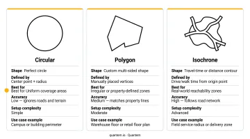
Most enterprise platforms support circular and polygon geofences. Isochrone geofences are available in more advanced platforms and are particularly useful for defining realistic delivery zones or service coverage areas.
Worth noting before moving on: geofencing depends on GPS-enabled devices and a connected management platform to function. It's the rules layer that acts on location data - which means the accuracy and reliability of your underlying tracking setup directly determines how well your geofences perform.
How Geofencing Works: The Technology Behind Virtual Boundaries
The Technology Stack
Modern geofencing draws on multiple positioning technologies working together:
- GPS satellites determine device position with high accuracy outdoors - GPS.gov reports smartphone accuracy of approximately 4.9 meters (16 feet) under open sky
- Cellular network data fills gaps when satellite signal is weak
- Wi-Fi positioning extends coverage indoors, where GPS signals degrade significantly
- RFID appears in specific industrial or indoor contexts for short-range asset tracking
Software on a central server then compares each incoming location update against stored boundary coordinates and fires the configured action when a match occurs.
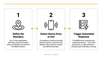
The Three-Step Geofencing Process
- Draw the boundary - An administrator defines a geofence in the management dashboard, setting its shape, size, name, and the actions to trigger on boundary events
- Device reports position - The managed device sends location updates to the server at configured intervals (Quantem's platform supports sync intervals from 15 minutes on Essential plans down to 2 minutes on Enterprise plans)
- Server evaluates and acts - The platform checks each update against active geofence rules and fires the configured response - push notification, email alert, device lock, compliance log entry - when a boundary event occurs
Geofence Event Types
Three event types cover most enterprise use cases:
- Entry - device crosses into the boundary
- Exit - device leaves the boundary
- Dwell - device remains within the boundary for a set duration
Dwell events are particularly useful for verifying time-on-site - confirming a technician spent the required minimum at a job, validating clinic hours for a healthcare worker, or generating an automatic attendance record.
Without dwell detection, a device that passes through a geofence zone and immediately leaves generates the same entry event as one that stayed for two hours.
Accuracy and Latency Realities
Expect these real-world conditions:
- Open-sky GPS accuracy: ~5 meters (16 feet)
- Urban canyons and indoor environments: accuracy degrades, sometimes significantly
- Recommended minimum geofence radius: 100–150 meters for mobile devices (Android Developers recommends this range; Apple's testing guidance references 200 meters plus a 20-second dwell minimum before notification delivery)
- Alert latency: Android 8.0+ limits background apps to location updates several times per hour; geofence responsiveness is typically every couple of minutes
These are platform constraints to design around. A geofence with a 50-meter radius around a building entrance will generate false triggers; one with a 150-meter radius around the same building will be reliable.
Where MDM Fits In
Unlike standalone GPS trackers that only show location, MDM platforms integrate geofencing directly into the policy engine. When a managed device crosses a boundary, the platform can enforce a policy response: lock the device, push a compliance log entry, or trigger an alert based on the event type.
Quantem's MDM platform includes geofencing and location tracking as built-in capabilities for Android and Windows device fleets. IT administrators connect boundary events to device-level actions through the same console they use for everything else.
Geofencing vs. GPS Tracking vs. Geolocation: Key Differences
These three terms get mixed up constantly - but they describe different layers of the same stack.
- Geolocation is the process of identifying a device's current coordinates using GPS, Wi-Fi, or cell data. Think of it as the foundation everything else builds on.
- GPS tracking uses that data to show where a device is right now and record where it's been - providing movement history and route replay.
- Geofencing uses location data to trigger automated actions when a device crosses a predefined boundary. It's where location awareness becomes actionable logic.
| Capability | GPS Tracking | Geofencing |
|---|---|---|
| What it shows | Live position and route history | Boundary crossing events |
| Data output | Movement logs, route replay | Entry/exit/dwell logs |
| Alert types | Speed, idle time, movement | Zone crossing, dwell time |
| Best use case | Theft recovery, route optimization | Attendance verification, access control, compliance |
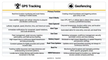
In practice, most enterprise deployments run both simultaneously - tracking gives you the historical record, while geofencing handles the automated triggers and alerts in real time.
Real-World Use Cases: Where Geofencing Delivers Results
Field Service and Workforce Management
HVAC companies, plumbing services, and home healthcare providers use geofences around customer addresses to automatically log technician arrival and departure times. When the technician's device enters the client-site geofence, the system timestamps the arrival. When it exits, departure is logged. No manual check-in required.
The dwell-time record serves as an audit trail for billing disputes - if a customer claims the technician left after 20 minutes but your records show a 90-minute dwell event, the conversation is over quickly.
Logistics and Fleet Operations
Warehouses and delivery fleets set geofences around distribution centers, customer sites, and delivery stops. When a vehicle enters a customer geofence, dispatch gets an automatic confirmation. When it exits, the system can log delivery time and trigger the next notification.
CargoNet reported 3,625 cargo theft incidents in the US and Canada in 2024 - a 27% increase from 2023, with reported losses of $454 million. After-hours geofence alerts that flag vehicle movement outside expected zones give fleet managers an early warning layer that traditional perimeter alarms can't provide.
Healthcare and Enterprise Device Management
Hospital networks and diagnostic chains deploy managed tablets across departments and clinics. A 2025 study in ScienceDirect found that 42% of healthcare organizations had annual mobile device loss rates between 11% and 30%, and 70% reported remediation costs above $250,000 for a single mobile data breach.
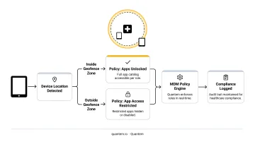
Geofencing tackles both directly. IT teams can detect when a device leaves an approved zone and trigger a remote lock automatically. Location-dependent app policies add another layer:
- A device inside a secure radiology department gets access to imaging apps
- The same device in a parking lot does not
- A device leaving the facility entirely can be locked or wiped remotely
Security and Unauthorized Use Prevention
After-hours geofencing filters let organizations detect equipment moving outside job sites on weekends, vehicles leaving approved routes, or company devices being used in unapproved locations. Unlike traditional alarm systems that protect a fixed perimeter, geofencing monitors the asset itself - wherever it travels.
Compliance and Access Control
Regulated industries often require location verification as a compliance condition. Gaming apps must confirm users are within state lines before allowing play. Enterprise environments restrict access to sensitive applications unless the device is physically within a secured facility. Geofencing enforces these policies automatically, with no manual verification required at any point.
Key Benefits and Practical Limitations
Primary Benefits
- Automated attendance records - eliminates manual check-ins and reduces payroll disputes
- Accountability without micromanagement - location logs create transparency for distributed teams without requiring constant supervisor contact
- Faster unauthorized-activity response - after-hours or out-of-zone alerts surface problems in near-real-time
- Reduced administrative overhead - dispatchers spend less time calling technicians to confirm arrivals
- Audit-ready compliance data - dwell logs and entry/exit records support billing verification, regulatory reporting, and legal disputes
Practical Limitations to Plan For
- Indoor GPS degradation - tunnels, dense buildings, and basement areas reduce accuracy; plan for larger geofence radii in these environments
- Alert fatigue - poorly configured rules generate noise that teams learn to ignore; use time-based filters (after-hours only) and asset-based filters to keep alerts meaningful
- Battery and data impact - background location tracking affects device battery life; adjust sync frequency based on operational needs rather than defaulting to maximum
- Ongoing maintenance - geofences need updating as job sites, customer locations, and operational zones change; stale boundaries generate false events
The Human Factor
Technical limitations are only half the challenge - getting employees to accept location tracking is where many rollouts stall. Address this upfront with three steps:
- Establish a written device-use or vehicle-use policy that explicitly discloses location tracking
- Communicate the business rationale clearly - why the organization is doing this, what data is collected, and how long it's retained
- Frame geofencing as a tool that benefits employees too - automatic time logging means they don't have to remember to clock in, and dwell records protect them if a customer disputes service delivery
Privacy, Legality, and Compliance
The US Legal Landscape
Geofencing on company-owned devices and vehicles is generally legal in the United States, provided employees are informed. The standard best practice is a written policy with employee acknowledgment before enabling location tracking. State laws vary: California's CCPA identifies precise geolocation data as sensitive personal information and grants consumers specific rights over its collection and use.
Organizations operating in Europe must also comply with GDPR, which requires a lawful basis for processing location data and sets strict limits on collection and retention.
The short version: you can do this legally, but you need to document it properly and be transparent with employees.
Practical Compliance Steps
- Get written acknowledgment from employees before enabling tracking on managed devices
- Collect only what you need - arrival/departure verification rarely requires continuous route logging
- Define a retention policy upfront and stick to it, specifying how long location logs are stored
- For BYOD programs, apply tracking only to the work profile, not the personal partition of an employee's device
Choosing a Compliant Platform
The compliance posture of your MDM vendor matters as much as your internal policies. Quantem holds SOC-2, GDPR, and CCPA certifications, meaning the platform meets recognized security and privacy standards for handling location and device data. For healthcare organizations, financial institutions, and enterprises managing devices across multiple locations, vendor certifications are a practical due-diligence checkpoint during evaluation.
Frequently Asked Questions
Does geofencing track your location?
Geofencing uses location data (GPS, Wi-Fi, or cellular) to detect when a device crosses a defined boundary. It logs events at those trigger points rather than continuously tracking or displaying a device's live position.
Is geofence location tracking legal?
Geofencing on company-owned devices and vehicles is generally legal in the US, provided employees are informed through a written policy. California's CCPA applies stricter protections around precise geolocation data, and GDPR governs any tracking of individuals in Europe. Always verify requirements under applicable state and local regulations.
What is the difference between geofencing and GPS tracking?
GPS tracking shows where a device is right now and maintains a historical route record. Geofencing triggers automated actions when a device crosses a predefined boundary. Geofencing is a rules-based layer built on top of GPS tracking - the two work together rather than replacing each other.
How accurate is geofencing?
Under open-sky conditions, GPS-based geofencing is accurate to roughly 5 meters (16 feet). Accuracy decreases in urban canyons and indoors. Use a minimum geofence radius of 100–150 meters for reliable triggering on mobile platforms under typical conditions.
What are the different types of geofences?
The three main types are:
- Circular - a center point and radius, best for single addresses or simple locations
- Polygon - a custom multi-point shape for irregular areas like campuses or building complexes
- Isochrone - a boundary defined by travel time rather than straight-line distance
Can geofencing be used for employee device management?
Yes. MDM platforms use geofencing to apply location-based device policies, such as restricting app access, running compliance checks, or alerting IT when a managed device exits an approved zone. It works across distributed teams, healthcare workers, and field employees with no additional hardware needed.