
Introduction
Fleet managers face a familiar frustration: a vehicle is late, equipment has moved overnight, or a technician missed a job site - and no one knows until a customer calls to complain. By the time you piece together what happened, the damage is done.
Geofencing changes that equation. Instead of reacting to problems after the fact, you get automated alerts the moment a vehicle crosses a boundary it shouldn't - or fails to arrive where it should. That means your team can respond in real time, not hours later when the situation has already escalated.
This guide covers what geofencing is, how it works, the types available, and how to build a strategy that keeps your team informed without burying them in noise.
Key Takeaways
- Geofencing creates virtual boundaries around real-world locations and triggers automated alerts when fleet assets cross them
- It runs on GPS, cellular data, Wi-Fi, or RFID - with GPS as the primary technology for outdoor accuracy
- Core benefits include theft prevention, productivity gains, compliance documentation, and reduced dispatcher workload
- Geofences can be static or dynamic, high-precision or approximate, temporary or permanent
- Fleet geofencing is legal in the US for company-owned assets - employees should be informed of monitoring practices
What Is Geofencing in Fleet Management?
Geofencing is a virtual perimeter drawn around a real-world geographic location (anything from a single loading dock to an entire service region). When a fleet asset (a vehicle, a piece of heavy equipment, or a mobile device issued to field personnel) crosses that boundary, the system executes a predefined action: sending an alert, logging an event, or triggering a workflow.
Beyond Basic GPS Tracking
GPS tells you where an asset is. Geofencing tells you when it crossed a boundary, how long it stayed, and whether that behavior was expected or anomalous. That distinction matters operationally.
A concrete example: GPS shows a delivery truck parked at a dock. A geofence tells you it arrived 40 minutes late, spent two hours beyond the expected dwell time, and then exited in the wrong direction. Same data source. Completely different operational picture.
This contextual intelligence is what separates geofencing from passive location tracking. You're not watching dots move on a map; you're getting notified when something deviates from plan.
Geofencing Applies to Device Fleets Too
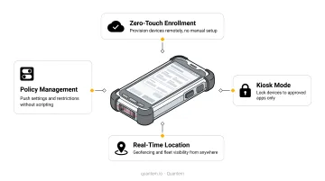
Most discussions of fleet geofencing focus on vehicles. But the same boundary logic applies to mobile device fleets - smartphones, tablets, and rugged handhelds issued to field technicians. MDM platforms like Quantem include location tracking and geofencing features that give IT and operations teams direct control over managed devices. Key capabilities include:
- Monitor devices within approved geographic zones in real time
- Receive alerts when a device leaves a facility boundary
- Maintain location history for compliance documentation
For organizations running both vehicle and device fleets, the underlying technology is the same - and so are the operational benefits.
How Does Geofencing Work?
The Underlying Technologies
Most fleet-grade geofencing relies on GPS as the primary positioning technology. According to GPS.gov, GPS-enabled devices are typically accurate to within 4.9 meters under open sky, with high-quality receivers achieving 1.82 meters or less 95% of the time - making a practical range of 3–10 meters for outdoor fleet applications.
Three other technologies supplement GPS in specific environments:
- Cellular triangulation - useful where GPS signal is weak; lower precision than GPS
- Wi-Fi positioning - can achieve 1–2 meters with Wi-Fi RTT, but limited to indoor/campus settings
- RFID - effective for controlled-access zones like warehouse gates or facility entrances
For most outdoor fleet operations, GPS with cellular data connectivity for transmission is the standard combination.
The Three-Step Technical Flow
Transmission - A GPS-enabled device in the vehicle or asset sends its coordinates to the fleet management platform. Location update frequency varies by system: Samsara collects data every second; Verizon Connect updates as often as every 30 seconds. For MDM-focused platforms like Quantem, update intervals are tuned to device fleet management rather than real-time vehicle tracking - the Professional plan syncs every 5 minutes, Enterprise every 2 minutes.
Comparison - The software continuously compares incoming coordinates against the geofence boundaries stored in the system.
Action - When the asset crosses a boundary, the system executes the preconfigured response: email, text, in-app alert, or an automatic log entry for reporting.
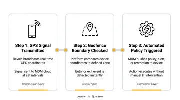
That Action step is where alert logic takes over - and how you configure it determines whether geofencing is genuinely useful or just noisy.
Alert and Automation Logic
Geofencing systems use if-then rule sets. For example: "If Vehicle A exits the depot boundary after 10 PM on a weekend, send an immediate text to the fleet manager."
Well-designed configurations account for recipient, time window, frequency, and communication channel. The practical goal: flag real exceptions, not every minor GPS drift that briefly nudges a device across a boundary.
Types of Geofences in Fleet Management
Matching the right geofence type to the operational need is where most teams either get it right or create unnecessary noise.
| Type | Description | Best For |
|---|---|---|
| Static | Fixed, permanent boundaries around recurring locations | Depots, warehouses, customer sites, restricted areas |
| Dynamic | Boundaries tied to another asset's proximity or movement | Proximity alerts between devices or assets in motion |
| Temporary | Time-limited zones that expire and delete automatically | Construction sites, road closure detours, seasonal operations |
| Permanent | Always-active boundaries requiring manual modification to change | Compliance-critical zones, high-security facilities |
Precision Levels Matter
Precision level shapes how reliably alerts fire - and how much noise your team tolerates:
- High-precision (polygon boundaries): Trace tight outlines around specific assets or areas. Critical for compliance auditing or security-sensitive zones where a 50-meter error can flip a status from "compliant" to "flagged."
- Low-precision (circular boundaries): Cover wider regions for general awareness. Knowing whether a device is in the right service area or facility zone is enough - broad circles also reduce false alerts caused by minor GPS drift.
A distribution center benefits from a permanent, high-precision geofence around its loading dock or restricted storage areas. A hospital network might use temporary zones during a facility expansion - remapping device boundaries to match active wards each quarter. The right combination depends on how your operations are structured and how tightly you need to enforce boundaries.
Key Benefits of Geofencing in Fleet Management
Productivity and Time Management
Manual check-ins between drivers and dispatchers eat time on both ends. Geofences automate arrival and departure logging at job sites, customer locations, and facilities - eliminating the phone calls and providing data to compare planned versus actual visit times.
Motive's 2024 fleet survey found that fleet employees waste an average of 5 hours per day on repetitive administrative tasks, with 57% of managers at fleets over 100 vehicles reporting that employees spend half their day or more on manual duties. Automated geofence logging directly reduces this burden.
Asset Security and Theft Prevention
High-value vehicles and equipment are attractive targets. Geofences trigger immediate alerts when an asset moves outside its designated boundary during off-hours - giving teams time to respond before a theft becomes a loss.
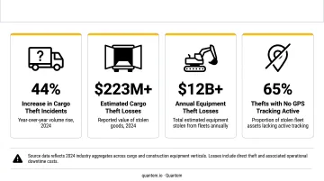
The scale of the problem is significant: Overhaul recorded 2,217 US cargo thefts in 2024, a 49% increase in volume from 2023, with average theft value also rising 17%. For equipment, the National Equipment Register estimates $300M–$1B in heavy equipment is stolen annually. An after-hours geofence alert doesn't guarantee recovery, but it compresses the response window from hours to minutes.
Compliance and Policy Enforcement
Geofences help enforce operational rules that are otherwise difficult to audit:
- Keeping vehicles within approved service territories
- Flagging trucks approaching restricted roads or low-clearance zones
- Documenting driver activity at required stops for regulatory reporting
- Supporting HOS compliance with automatic boundary-crossing timestamps
The FMCSA's ELD Final Rule governs how CMV location data is recorded. Non-recordkeeping violations can reach $19,246 per carrier violation - making accurate, automated location documentation worth taking seriously.
Fuel Efficiency Through Idle Reduction
Geofence activity data reveals inefficiency patterns that are invisible without boundary monitoring: vehicles idling outside designated zones, unauthorized stops, routes that deviate from assigned paths.
The DOE reports that a typical long-haul combination truck eliminating unnecessary idling can save more than 900 gallons of fuel per year, at roughly 0.8 gallons per idling hour. Geofence-triggered idle alerts at unauthorized stops turn this from a theoretical savings into an actionable intervention.
Fleets using GPS tracking with these features saw an average 12% decrease in fuel costs, per Verizon Connect.
Customer Experience
A geofence around a customer's facility can automatically trigger an ETA notification when a delivery truck enters the 10-mile perimeter - reducing inbound "where is my delivery?" calls and giving customers visibility without requiring dispatcher intervention. That kind of proactive communication cuts complaints and frees dispatchers to focus on exceptions rather than status updates.
Geofencing Use Cases Across Industries
Transportation and Logistics
Geofences around loading docks and distribution centers reduce detention costs by alerting receivers before a truck arrives. OOIDA's 2023 Detention Time Survey estimates detention costs for-hire drivers $1.1B–$1.3B annually and reduces individual driver earnings by $1,281–$1,534 per year. Arrival alerts that shave even a fraction of that time translate directly to recovered driver income.
Compliance teams also use geofence records to confirm vehicles made required stops and stayed within approved corridors - creating an automatic audit trail that manual check-ins can't reliably produce.
Construction and Field Services
Construction companies use geofences to:
- Detect unauthorized after-hours equipment movement (early theft warning)
- Define hazardous on-site zones where unexpected entry triggers safety alerts
- Verify that equipment stays within assigned project boundaries
Field service organizations - repair crews, home health aides, utility technicians - use geofences to verify job-site arrival, automate timekeeping, and confirm billing accuracy. SmartBarrel documented one case where automated time-log verification helped a firm reclaim $2.6M annually in overreported labor hours.
Healthcare and Regulated Industries
Healthcare fleets - hospital vehicle networks, home health agencies - use geofences to:
- Log when staff vehicles arrive at and depart from patient locations
- Ensure vehicles stay within approved service regions
- Support EVV (Electronic Visit Verification) compliance documentation
Medicaid's EVV requirements, mandatory for Personal Care Services since January 2020 and Home Health Care Services since January 2023, require verification of service location and start/end time. Geofencing automates much of this documentation.
The same logic applies beyond vehicles to managed device fleets. For home healthcare agencies, MDM platforms like Quantem use geofencing to alert IT teams when a tablet or handheld assigned to a field worker leaves an approved geographic zone - supporting both asset security and compliance documentation in a single automated step.
How to Set Up and Manage a Fleet Geofence Strategy
Setting Up Geofences
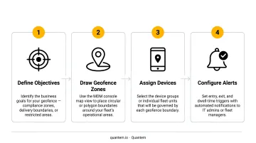
Follow these four steps to build a geofence strategy that works operationally:
Define your objectives - Identify what you need the geofence to do: improve dispatch accuracy, detect theft, verify job-site visits, enforce territory boundaries. Clear objectives prevent overlapping or redundant zones.
Choose your locations - Start with the highest-value sites: primary depots, key customer facilities, high-theft-risk equipment yards. Don't try to geofence everything at once.
Draw boundaries in your platform - Use the map interface to set perimeter shape, precision level, and zone type. Polygon boundaries for tight compliance zones; circles for broader regional awareness.
Configure alerts and rules - Set who gets which notifications, via what channel, under what conditions. Time-window restrictions (alerts only after 6 PM on weekdays, for example) reduce noise significantly.
Alert fatigue is a real risk. Start with a small number of high-value geofences, review alert volume after two weeks, and iterate before expanding. A well-tuned alert set - even a small one - delivers more operational value than a sprawling system nobody acts on.
Once your geofence configuration is in place, the next layer to address is compliance - because how you collect and use location data carries its own requirements.
Legal and Privacy Considerations in the US
Geofencing for fleet management is legal in the United States. Employers have the right to monitor company-owned vehicles and assets. That said, best practice - and some state laws - require that employees be informed of monitoring policies, ideally documented in employment agreements or fleet policy handbooks.
Key state-level considerations:
- California - Penal Code 637.7 restricts electronic tracking devices. Written notice and clear employee consent are strongly recommended for GPS monitoring programs.
- Connecticut - General Statutes 31-48d requires prior written notice to employees before electronic monitoring begins.
- New York - Civil Rights Law 52-c(2) requires private employers to provide prior written notice for certain electronic monitoring (effective 2022).
The FMCSA's ELD mandate addresses driver privacy directly: per 49 CFR 395.26, location precision during authorized personal use is reduced to approximately a 10-mile radius, compared to the 1-mile radius recorded during on-duty driving.
Organizations operating across multiple states should have legal counsel review their monitoring policies. Store geofencing data securely and limit access to personnel with an operational need. Treat both requirements as non-negotiable criteria when evaluating any fleet management platform.
Frequently Asked Questions
What is geofencing in fleet management?
Geofencing in fleet management is the use of virtual boundaries defined on a digital map to automatically trigger alerts, log events, or initiate workflows when a vehicle, equipment unit, or device crosses into or out of a designated area. It enables managers to monitor fleet activity in real time without manual check-ins or IT oversight calls.
Is geofencing legal in the US?
Fleet geofencing is legal in the US for company-owned assets - employers have the right to monitor company vehicles and equipment. Employees should be informed of monitoring practices per best practice and certain state laws. The FMCSA's ELD mandate also includes privacy protections that reduce location precision to a 10-mile radius during off-duty hours.
What technologies does fleet geofencing rely on?
GPS is the primary technology for outdoor accuracy, typically achieving 3–10 meters under open sky. Cellular triangulation, Wi-Fi positioning, and RFID supplement GPS in indoor or signal-limited environments. Most fleet management platforms - whether for vehicles or managed devices - combine GPS with cellular data connectivity to transmit location events in near real time.
What is the difference between static and dynamic geofencing?
Static geofences have fixed boundaries around permanent locations - facilities, job sites, restricted zones. Dynamic geofences move or adapt based on conditions, such as tracking proximity between assets. Dynamic geofences suit scenarios where the reference point is itself in motion; static geofences work for stable, recurring operational locations.
How accurate is fleet geofencing?
GPS-based geofencing is typically accurate within 3–10 meters under clear sky conditions. Accuracy degrades in urban canyons, tunnels, and areas with signal interference. Using tight polygon boundaries rather than broad circles reduces false alerts in dense environments, and some systems use dead reckoning to maintain accuracy through signal gaps.
Can geofencing be used for device fleets, not just vehicle fleets?
Yes. Geofencing logic applies equally to mobile device fleets. MDM platforms can define boundaries around facilities, job sites, or service territories and alert IT or operations teams when a managed device leaves an approved zone. This is particularly useful for field service organizations and healthcare teams managing issued devices.